French Polynesia Sights
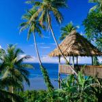 French Polynesia attracts tourists the beauty of its nature - the picturesque atolls and no less colorful volcanic islands, the sea of green, a rich underwater world with a huge variety of inhabitants, as well as many kilometers of beaches of pure coral and volcanic sand. Each island - it is their appearance, their flora and fauna, and even their customs. Identity of the local population are the descendants of the famous "Sea Peoples" who performed on their leaky canoes throws across the Pacific, is still carefully preserving their traditions and their own special way relationship with their surroundings.
Tahiti
Tahiti, often called the "Island of Love", is the largest of the islands of French Polynesia (area of about 1,045 sq. km.). Volcanic in origin, the island is mountainous, formed by the slopes a few dozen peaks, whose peaks rise to a height of more than two thousand meters (highest point - Mount Orohena, 2241 m), and a network of deep green valleys between them. Two cones of ancient volcanoes form a vast peninsula of Tahiti-Nui and Tahiti-Iti, joined by an isthmus plateau Taravao.
The capital of the island and throughout - the city of Papeete, is located on the northwest coast of Tahiti. The capital of French Polynesia has a population of only 70 thousand people, and is "very European" of all localities in the country. Only the abundance of palm trees and visible from almost all points of the ocean, can visually take it to the tropics. Here are many offices, clinics, banks, travel agencies and shops are constantly seething business life, build something, loud horn car in traffic, come and depart yachts and cruise liners, where it sounds the next music festival or sporting event crowd roars . The city deserves to be here for at least half a day and get acquainted with its attractions. Of interest is visiting the area To'ata, where are all the cultural activities of the capital - the audience is specially built to hold various ceremonies and seats up to 5000 people. By Bruat Avenue are nearly all government agencies - office building of the High Commissioner, several ministries and the Presidential Palace French Polynesia. Bougainville park surrounds the building of the General Post Office, and on the square stands the statue of Tarahoi Pouvanaa Goria - "spiritual father" of internal autonomy, as well as Polynesian Territorial Assembly. A little further along the coast stretches the main shopping district of Papeete - Vaima Center, which focused a lot of shops, bars, restaurants, etc. Behind Vaima Center towers the cathedral of Notre Dame of Papeete, which was built in 1875 and rebuilt in the late 90 -x. Behind the cathedral begins mission area-District, the center of the Catholic Church in French Polynesia, the residence of Bishop (XVIII century - one of the oldest buildings in the city).
Toward the center of the city can find a beach Sihon - rowing center and slightly to the right - the church Paofai (1990) - the main center of Protestantism in Tahiti and the largest in French Polynesia. Also noteworthy excellent Harrison Smith Botanical Gardens, garden Mataoa rich Museum of Tahiti and the Islands, with its extensive collection of cultural and historical exhibits, the Museum Ocean Lagunarium in Punaauia, the Museum of Du Kukilazh, a famous Gauguin Museum (just a small hut with the works artist), as well as a wealth of Tahiti-Pearl Center, which collected rare samples of the famous local black pearl ( "pinctada margaritifera").
Shopping district of Papeete is a vast territory in the quarter from the coast, in the old Chinese settlement. All this vast territory is built up shops, shops and stalls, where you can buy virtually everything from fruits and flowers, and ending with seafood and handicrafts. In the middle of this picturesque disorder rises a new two-storey Central Market of Papeete (an area of 7000 sq. M) - the building market was built in 1987, but it closely follows the architecture of the old market, built on this spot in 1860, believe that the market Papeete is one of the few places where you can see the real Polynesia.
On the high hills around the city spread out colorful neighborhoods, surrounded by tropical gardens and miniature parks. The most picturesque places are the slopes of Peak-Rouge, Saint-Amelie, Orovini and Misión. If you move from Papeete to the east, you'll find a hospital and the old mother Chinese temple, still guarded by two dragons. And just south of the road, by the way, she goes around the entire island, resulting in one of the most beautiful places on the island - the valley Fautaua. Nestled between the peaks of Mount Aorai (2066 m) and Diadema, Fautaua replete with waterfalls and luxuriant vegetation, therefore, is under state protection. Just a few kilometers inside the island, and the road goes to the river Fautaua and legendary waters Bajina Loti. Seaside village Tipaerui widely known as a center of traditional local crafts, where you can buy, probably the best handicrafts of the island.
Magnificent interior of the island of Tahiti offers many opportunities for hiking in the mountains, and even climbing. Also, you'll find several scenic plateau, about three dozen waterfalls, the famous "lava tubes" in Faaruumai and numerous Polynesian relics, including several ruined temples, Arouet town - the burial place of the last king of Tahiti Pomer V, many "ticks" (ritual stones) "blue hole" in Arahoho and petroglyphs in the Marae-Arahurahu. A number of magnificent beaches, around the perimeter of the island simply defies description. In addition, the water around the island full of coral reefs that create excellent conditions for diving and snorkelling. The island of Tahiti is the birthplace of surfing, and popular places to "play with the wave can be found in Papenoo, Punaauia and Paea.
Moorea
The island of Moorea, in particular bore the names of Eimeo or Aimeho, located 17 km north-west of Tahiti, and occupies an area of 136 sq. km with a population of only 14 thousand people. Moorea - an island of volcanic origin, "grew up" on the surface of the ocean about 2 million years ago. Eight of its jagged peaks form this mountain landscape, with the highest point on Mount Tohiee (1207 m). Other volcanic cones form several branched ridges, which snap into the ocean by numerous capes and bays, which makes the island look to stretch their wings a bird. The unique geology of the island forms the two large bays - Opunohu on the west side of Mount Roth, the former crater of the volcano, and Cook Inlet on the east side. The mountain slopes are covered with forests and fruit plantations, and white sandy beaches bordered on the perimeter of almost the entire island. A coral reef is located very close to the bank and has seven channels, three of which are available for large vessels.
Along with the Bora-Bora, Moorea is one of the most beautiful islands in the South Pacific Ocean, perhaps - and the world. This is a casual island with long white beaches, turquoise lagoons and lush green mountains. Its main enticements include the Folk Village Tiki regular ethnographic representations, observation platform and Belvedere Toatea in Tema, a beautiful beach at the Sofitel hotel, the stone temples "marae" (scattered around the island, the oldest - in Afareaitu), an excellent yacht parking lot in the grand Cook Inlet, the place of the first landing on the island of Captain Cook (1769) - Gulf Opunohu, waterfalls Afareaitu, Dolphin Center in the Intercontinental Hotel, and numerous small islands "motu off the coast.
By the way, "marae" in the life of the Polynesians have played a huge role. Usually this term is interpreted as "temple" or "sanctuary", but in local tradition, this term has a much broader interpretation - "marae" for Polynesians regarded as living beings, which concentrated all their ideas about the spirits and forces of nature. They were cult centers, and the place of courts and festivities, there were sacrifices, they erected the new lands in the first place, and they are primarily transported to a new residential community. Therefore, even dilapidated, they still serve as a place of worship and worship.
Tetiaroa
Located approximately 40 km north of Tahiti, the island of Tetiaroa, better known as "Island of Marlon Brando," in honor of its former owner. This is the only coral atoll in the chain of volcanic Windward Islands, a small but very beautiful, with magnificent beaches, crystal-clear water of the lagoon and thousands of migratory birds. It does not live more than 50 people, but there is a real hotel in the village of Tetiaroa and thousands willing to come here on vacation.
Leeward Islands
Leeward Islands lie northwest of Tahiti, and is an archipelago of very popular among tourist island of Bora Bora, Raiatea, Tao (Tahaa), Tahiti and Maupiti and Tupai uninhabited atolls, Mopelia, Scilly and Bellinghausen.
Bora Bora
The most popular of the islands of French Polynesia, Bora Bora is located 280 km north-west of Tahiti. Bora Bora has an area of only 29 square. km, but the lagoon covers an area three times larger - about 83 square. km, and is considered the most beautiful lagoons in the world. Who has a rather intricate shape, the main island is located in the heart of this vast lagoon, which, in turn, the ring surrounds the entire chain of small islands "motu", forming a single pass into the lagoon from the south-western side. The highest part of the island, Mount Otemanu (727 m), is a cone of an extinct volcano, whose age is estimated at 4 million years. On the island itself resides about 6 thousand people, but luxury hotels are more than all the other islands of French Polynesia, taken together, all beaches are public, and access to them absolutely free. Here everything is for the sake of tourists, but locals are trying to preserve the natural environment and Bora Bora - in a lagoon inhabited by about 700 varieties of tropical fish, the green slopes, grows about 60 varieties of plants and species diversity of birds, one of the richest in the archipelago.
In the area Ninhue, the most populous and the most active part of the island, home to more than half of its residents. Occupying almost the entire western coast of the island, this area since ancient times been the scene of the royal family vacation Maui. The main city and port of the island - Vaitape, built at the foot of the imposing cliff of Mount Paia, directly opposite the only passage in the wall of the reef - Teavanui. Are concentrated in all public establishments, post office, the gendarmerie and schools, as well as several hotels and a local museum. In the southwestern part of the lagoon stretched "Coral Garden" or "Lagunarium" - an amazing natural underwater park, inhabited by almost all types of local fish, including almost tame stingrays, moray eels and sharks (they are quite easy to hand feed), and also a large population of dolphins. A few meters away from Matira Point, on the southern shore of the island, there are magnificent beaches Petey-Uta and Toopua, which abound in the waters near the mantle. Not far away, an aisle Teavanui, is "singing rock" Hiroshi-Bell, and in the passage, which has a depth of about 55 meters, you can see has never stopped "ballet" of tens and hundreds of gray sharks and barracudas. Unique semisubmerged ship Akvaskop "was developed by Jacques Ruzheri - a close friend and colleague, Jacques-Yves Cousteau, and for 15 years now carries tourists to the magnificent lagoon of Bora Bora.
Near Faanui, north Ninhue lies eponymous bay, around which are concentrated cassava plantations and copra driers - here are the main agricultural areas of the island. In Outuorahu noteworthy Maritime Museum, in the Gulf Faanui - the old base of amphibious and submarine in the Marae-Phare-OPU - mysterious petroglyphs depicting sea turtles, and on the island of Marae-Farurea the graves of the ancient rulers of the island. Also here you can find a half dozen of the old military bunkers and gun caponiers remaining in Faanui since the Second World War, when 5000 American soldiers have carried out the "peaceful seizure" of the island. District Anau lies on the eastern side of the island and has lots of not less interesting places - a beautiful lagoon at the foot of Motu Piti-Ou, the majestic slopes of Mount Otemanu (727 m, while the locals claim that no one rose to its top) and quiet island Marae-Nonohaura.
Bora Bora is not as rich in historic sites, like its neighbors, but the island can be found 42 traces of the ancient Polynesian civilization, including the "marae" in the northern Gulf Vaiotaha Poovai, Farerua or Marotetini - the biggest ceremonial stone on the island, and also one of the most beautiful in Polynesia "marae" Taianapa. People of the island still remember a lot of legends and traditions, and with great pleasure to retell them to tourists.
Hin
Island of Tahiti, has earned the locals nicknamed "Wild" - the most eastern of the Leeward Islands. Located 175 kilometers west of Tahiti, Tahiti has an area of 76 square. km and consists of two islands - Tahiti Nui ( "big") and Tahiti Iti ( "small"), formed by the invasion of land Maroe deep bay, which, according to local legend, was due to the impact of the god Hiro canoe, and, without doubt, is one of the most beautiful bays of Polynesia.
Hua Hin is the most mystical place in French Polynesia, and one of the largest archaeological sites in the Polynesian triangle. It was on this island have been found the best-known tracks of ancient Polynesian culture, among them the oldest known to date sites civilization Maui - Fa'ahia and Vaito'otia Related to 800-900 years. Mr. e. In 1972, during the construction of hotel Bali-Hai about Phare, was found buried in a large concentration of ancient swamp items Maui (now they are displayed in the exhibition hotel). On the shores of Lake Fauna Nui, the hill Matairea, worth about thirty "marae". Noteworthy Manunu-in Maeva Marae and Marae-Anya on the south side of the island, Pare, and flower plantations Paradise Park.
The most beautiful beaches are located on Tahiti Iti Pare in the area, as well as on the west coast near Faauo and Haapu, not to mention the magnificent beach at the Hotel Bali Hai. Laguna Tefarerii, located on the eastern shore of Tahiti Iti, is one of the most beautiful in French Polynesia. Another feature of Huahin, which attracts thousands of visitors to the island, is described in all textbooks, the phenomenon of "green light" - at the time of leaving the sun behind the horizon flashes of emerald green light, which is formed by a special refraction of sunlight in the earth's atmosphere. It is said that Hua Hin - the best place on the planet for observing this phenomenon.
Raiatea
Located at a distance of 220 km north-west of Tahiti, Raiatea Island (Havaiki, Havaii'Nui) is the largest and highest in the Leeward Islands. The island - 172 square. km, the highest point - Mount Tefatua (1017 m). Together with the nearby island of Tao (Tahaa), Raiatea lagoon forms a single Faaroa - the deepest bay in the whole of Polynesia (30 m). The island is practically no good beaches, but also attracts people is not it - the administrative center of the whole island group, Raiatea now fifteen hundred years is the honorary title of "sacred island". Which is not surprising - is considered the cradle of Polynesian civilization, the island was a place of worship as it previously inhabited by the Maori, and have come a little later Polynesians. According to legend, with Raiatea journeyed ancient Maori navigators who discovered hundreds of islands of the Pacific Ocean from New Zealand to the Hawaiian Islands.
The main place of worship here - the biggest "marae" in Polynesia - Taputapuatea. Marae-Tain, lies on the western coast of the island, was built as a complete copy of Taputapuatea. According to legend, it is these "marae" assembled clerics of the most remote Polynesian islands, it is here that brings "general" of the victim and it is here to solve global issues. Recent archaeological excavations have revealed many previously unknown 'marae', as well as fragments of terraces, tools, cult objects, weapons, and petroglyphs, especially abundant in the valleys and Haapapara Avera. And how many more unsolved mysteries of history hidden under the canopy of lush forests covering the slopes of local mountains? On Mount Temehani (772 m), and more than anywhere else in the world, is growing a unique and carefully guarded by local residents plant - tiara-apetahi ( "Tiare Apetahi"), the beautiful white flower with four petals. Its uniqueness lies in the fact that flowers bloom only at dawn, while still emitting a crackling sound. You can see this little miracle and not getting up in the mountains - in Faaroa is a beautiful botanical garden.
Tahaa
Taha, or "Vanilla Island", is located in a lagoon with Raiatea. The island, about 89 kv. km, and the highest point is at the top of Mount Ohira (590 meters) - an ancient volcano, whose numerous secondary cones form a very rugged coastline. Reef surrounding the island has a length of nearly 160 km, forming the northern and north-eastern parts of more than 60 islands, "Motu," in which there are several hotels. The main attraction of the island - his 8 on the isolated and very different from each other's villages, the main of which is called the Patio. Almost 90% of the island's population grows vanilla - 76% of the total crop of vanilla in French Polynesia are collected here. For tourists spend tours of plantations, showing both rows of orchids, and the process of pollination and maturation of vanilla.
The most famous archaeological sites of the island are located in bays Vaimai and Mao. In Vaimai can see three "marae", one of whom has a well-preserved "Ahu (ceremonial platform) longer than 20 m. In Mao, there are five" marae "and some" paepae (ritual area) with a broad stone bridge between them. Hibiscus Foundation, located in the eponymous hotel, since 1992 has worked to protect and care for sea turtles, fishermen in buying all the copies of this endangered animal, and then releasing them back into the ocean. Also, the traditional place of attraction here are the many farms to grow pearls, among which the most picturesque farms and Vaipoe Poerani the Gulf Haamene and Motu in Faaha-Teuri. In Polynesian black pearls have always been synonymous with purity and magic, so it is not surprising that at present the Polynesian islands are the leading exporters of black pearls in the world.
Tupai
Tupai, or Motu Iti, located 16 kilometers north of Bora Bora. The island is seboy number of successive "motu" surrounding the shallow inner lagoon. Outer Reef is a narrow one, reaching a width of 1500 m just to the south-west side, and on the north atoll has a pronounced "beak", where the local airfield. Coconut trees, thick cover cover all the "motu", creating perfect conditions for life, and nesting birds and sea turtles. In Polynesian mythology Tupai was considered a stop to the souls of the dead. Perhaps that is why nobody lives here and there is no tourism infrastructure, but the island is regularly visited by divers and yachtsmen.
Still farther to the west lie the uninhabited atolls Mopelia, Scilly and Bellinghausen, non-margin and border of French Polynesia.
Marquesas
"Land of Men", or the Marquesas Islands, lies in a half thousand miles to the north-east of Tahiti. The archipelago consists of 12 islands (Nuku Hiva, Nuku OVA, Ua Pou, Tauata, Fatu Hiva, Hatutu, Eiao, hut Iti, Motu One, winding, Fatu Huku and Clark-Bank) and is located very close to the equator. The climate is dry, with very small temperature difference, which provides good conditions for development of agriculture and fishing. Field of the archipelago is considered the richest fisheries in the whole of Polynesia.
Nuku Hiva
Island of Nuku Hiva, or "majestic island" (the old name of Adams and Merchant), located 1500 km north-east of Tahiti. Occupying an area of approximately 365 square. km, Nuku Hiva - the second largest island in French Polynesia. The island consists of two nested old volcano, which formed two concentric calderas. In the center of the island stands the vast plateau Toovii left over from the first of the caldera, and the second caldera surrounding the capital of the island Taiohae, forming a deep bay (former crater) and the impressive wall of mountain peaks around. North Coast is heavily indented, exposing basalt ridges of striking beauty. Luxury bays Hatiheu, Haatuatua, Taipivai Taiohae and excellent for snorkeling, and imposing cliffs of the north-east plunge of 200-300 meters into the ocean, which in this area, most often, truly deserves its name - the Pacific Ocean.
The capital of the island - Taiohae, which in reality is just a picturesque village, situated on the banks of the picturesque bay, and is famous for its beautiful cathedral of Notre Dame, with excellent carved bas-reliefs, and a relaxed atmosphere. Also noteworthy Muake hill (864 m) with stunning panoramic view of the island, art studios on the outskirts of the capital, waterfalls and rich archaeological sites Taipivai Valley (16 km from the capital), a statue of the Virgin Mary on top of one of the peaks towering over your favorite bay RL Stevenson - Hatiheu, ceremonial Polynesian Naniuhi-Tohu in the homonymous valley, as well as the Catholic Church in Anah - the smallest church in the islands, and snow-white beach is almost at its walls. But the main center of attraction on the island - the majestic valley Hakaui 15 kilometers from the capital, on the south-west coast. Here is a small, deep bay, into which several cascading waterfalls, the highest of which - Waterfalls Ahuii, has a height of more than 350 m.
Hiva Oa
Island of Hiva Oa is located 1250 km north of Tahiti, and occupies an area of about 325 square. km at a maximum altitude of 1213 m (Mount Temetiu). Hiva Oa to the middle of XX century was the administrative center of the Marquesas Islands, and though this status is Nuku Hiva, Hiva Oa but still dominates the southern group of islands. On this island lived and worked in Paul Gauguin and Jacques Brel (both buried in the cemetery Kalwaria in the main town of the island - Autona, their graves are still present in places of pilgrimage). Here you can see such wonderful places as built by Gauguin "House of Pleasures" (restored in 1994), a giant amphitheater bay Autona, occupying the caldera of an ancient volcanic valley Puamau with its petroglyphs and a lot of "marae", a luxurious beach in the Gulf of Naohe very picturesque village Hanaiapa, petroglyphs in Eiaone and Pune, "marae" and the beach of black sand in Taaoa and nice bay Hanamenu.
Ua Pou
Island of Ua Pou, which can be translated as "pillars", is located 50 km south of Nuku Hiva, in the northern group of the Marquesas archipelago, and covers an area of about 108 sq. km. Through the entire island from north to south, runs a powerful volcanic ridge, reaching a maximum height on the mountain Potainui (1235 m). His highly indented coastline abruptly into the sea, only in the bays can be found suitable for the mooring of vessels plots, and they were extremely small. Only on the northern coast there are some good sites like beautiful bays Vaiehu or Hakahau. The south-west of the island lies the Gulf Hhohho, well-known beautiful beaches and flower stones "that are the boulders are naturally decorated with floral motifs (clearly visible only when the surface is wet stones). Jaca-Hawk and Hakahau, south-east of the island, found a range of "Pae-Pae, stone bridges and walls. The newly constructed on the road to Hhohho Catholic Church is decorated with colorful sculptures of local artists. But the main attraction of the island - bay Ua Pou, which you can see the huge basalt columns, voznosyaschiesya in the sky.
Ua Huka
Name of the island Ua Huka (Va-wook), which lies 50 kilometers east of Nuku Hiva, can be translated as "stock of the gods. The island is a vast plateau (total area of the island of 85 sq. Km.) Surrounded by desert areas, rising to a height of 855 m above sea level. Here there are more horses and wild goats than people, and the scarcity of water greatly complicates the life of the inhabitants of three small villages, hidden in the folds of the rock in the small bays along the south coast. However, his name Ua Huka was obviously a reason - when something is rustling the forest and lived more than 8000 people, so to have survived numerous archaeological sites and mysterious structures Peoples of the sea.
The main settlement on the island, the village Vaipaee, is proud of its archeological museum, which includes a vast collection of various household items, weapons, ornaments and tools found during excavations on the island. Also, you'll find only in French Polynesia Nursery (local authorities are crying restore the flora of the island), a vast archaeological site in the Gulf of Hania with three "ticks" in excellent condition, Municipal Museum in the village Hokatuis (created by the local people, objects, his decorating for the most part are family heirlooms), and even botanical garden! The most beautiful beaches Ua Huka can rival the best beaches throughout the island group. To the best of the best include the snow-white sandy beach Manihina, which lies on the east coast beach Hatuana, as well as relatively small, but very beautiful beach of Motu Papa. Near Vaikivi laid dozens of hiking and equestrian trails, going to the patchy rocks petroglyphs, and in Meiaute (Khan) are three "ticks" at a height of 3 meters.
Tauata (Tahuata)
Origin of the name Tauata can be found in the Polynesian word "dawn", but locals often call it "an island of birds." The island is located 4 km south of Hiva Oa and separated from it by a wide strait with powerful currents. Area Tauata about 60 sq. km. km, and the highest point - 1050 m. It is home to 3 times less inhabitants than at Hiva Oa, where they are scattered through 4 villages, each of which is located in a valley opening to the sea with a small bay. Port is not here, so all goods and people transported to shore in conventional fishing boats, which in half an hour, perhaps, the locals will go back into the sea.
Main village of the island - Vaitahu, very proud of its history. Here you can find a monumental Catholic church with stone walls and beautiful stained glass windows (the building of the church was financed directly by the Vatican, opened in 1988), as well as three of the memorial - in honor of the arrival of the Spaniards in 1595, Mr., in memory of the victims of clashes between locals and the French armed forces in 1838 g, and in memory of landing on the island of Admiral Dyupeti-THOIRY in 1842. Also it is necessary to see the old stone road from the village Hapatoni to the church by the sea, or take a guided tour on horseback, or on a boat in the Gulf Hanamoenoa, famous for its beautiful beach.
Fatu Hiva
The southernmost island of the Marquesas Islands, Fatu Hiva lies 30 km south of Hiva Oa, and occupies an area of 83 sq. miles at a maximum altitude of 960 m. The island's name can be translated as "nine parts of the roof, but more often it is called the" Garden of Eden "- this is the most moist, most luxurious and most traditional of all the islands of the group. Many fruit trees thrive on the slopes of the island due to heavy rainfall and smooth weather, and is grown here, "tapa" is exported to many countries in the region. On the island home to many of the finest craftsmen of French Polynesia - are woven colored cloth from plant fibers, cut wood and stone, and even prepare meals for special recipes.
Virgin Bay is world famous for its amazingly beautiful basalt peaks. In Omoa can see ancient wooden buildings which were built in the Marquesas Islands long before Europeans arrived, as well as a rock with petroglyphs at the exit of the village, a forest of trees between the grain and Omoa Hanavave, and many ancient ruins, abundant scattered throughout the island. The famous Norwegian explorer Thor Heyerdahl lived on Fatu Hiva in 1937-1938, and wrote about his impressions of the book, whose title is still the unofficial motto of the island - Fatu Hiva, the return to nature.
Tuamotu Islands
Tuamotu-Gambier Archipelago is the most extensive of the five archipelagos of French Polynesia. Its 78 islands have more than 2 million square meters. km, extending from the large north-west to the tiny atoll Mataiva south-east of the atoll Temoe, which shares about 2000 km. But the islands themselves have a total area of only 775 square. km, as most of them is a small coral atolls, only Makatea and four islands in the Gambier group are of volcanic origin. Up to 98% of the Black Pearl - the main treasures of French Polynesia, mine is on the islands of Tuamotu. But most importantly their treasure - a clean sea, deep lagoons and an amazing abundance of underwater life. These dairy coral ring surrounding the magnificent turquoise lagoon, is the dream of all divers world.
Rangiroa
Located 370 km north-east of Tahiti, Rangiroa Atoll ( "Long Sky") has a diameter of 230 km. This is the second largest atoll in the world after the Kwajalein Atoll in Micronesia. Its lagoon area of 1,640 sq. miles could accommodate the entire island of Tahiti. Famous for its incredibly clear water (on average up to 25 m) and abundant marine fish fauna, Rangiroa is widely known as one of the best places in the world for diving and snorkelling. The only inhabited part of the atoll - a ten-string of islands connected string of bridges. In the southern part of the atoll is a luxury resort Kia-Ora, accessible only by sea. Sleepy village Avatoru, the chief town of the island, has deployed on its territory a few high-quality resorts, many small hotels and several dive centers. Rangiroa has a few farms to grow pearls, which are also worth a visit.
Tikehau (Tikeyao)
Tikehau Atoll, first bearing the name of Oropaa, located 30 km from Rangiroa and approximately 300 km north-east of Tahiti. Diameter of its lagoon about 28 km with an area of about 80 square meters. km, which makes it one of the best natural aquarium in the world. Here are first-class farm growing black pearls, is found about 400 species of fish and 200 species of marine molluscs. "HOA" (channels between the islands) is literally teeming with marine life, and their depth makes it possible to consider all the details of the underwater kingdom with the boat. Islands "motu" are home to several species of sea birds that build their nests directly on the surface, which allows to observe them without leaving the shore, straight from the boat. Islands atoll of overgrown coconut groves, and fantastically beautiful beaches of coral sand has a pink hue. Not surprisingly, the island's 450 inhabitants live in tourist services, fishing and copra production. Jacques-Yves Cousteau Tikehau considered one of the most spectacular atolls in the world, and the diversity of local marine life makes it one of the best places on the planet to study the life of the sea.
Manihi
Manihi Island (atoll Poerava) located 520 km north-east of Tahiti and has a size 27 to 8 km. This is one of the smallest tourist islands. Its population of 750 persons, of whom 600 live in the village Paeua located directly opposite the main passage in the reefs Tairapa and 3 km from the airport.
Manihi - the cradle of Polynesian black pearls (often well known - "poerava"). Abundance pearl ( "pinctada margaritifera") in the lagoon of Manihi was known from time immemorial, so it is here in the early 60's was built first in French Polynesia on the plantation of artificial cultivation of pearls. Today there more than thirty farms, producing a year from 50 thousand to a million first-class pearls. Local pearls, which is called the black, actually has a lot of colors and shades, and reaches the impressive size, which determines its value. A lagoon is an atoll - a real paradise for lovers of scuba diving.
Fakarava
Opened in 1820, FF Bellingshausen Atoll Fakarava ( "End of the World", the old name of the headlamp or Havaiki), lies 560 km north-east of Tahiti. Strongly elongated in the shape of an irregular oval shape, the atoll has a size 60 to 25 km and only 2 passes through a ring of reefs - Ngarue and Tumakohua. The huge lagoon Fakarava - a paradise for any diver, widely known for its fantastic underwater landscapes and huge populations of stingrays, hammerhead sharks, tiger sharks, etc. At present, the entire atoll has the status of a Biosphere Reserve by UNESCO, which manages nearly pristine ecosystems of coral atolls central Pacific Ocean. Also worthy of attention on the cultivation of pearl farm, farm, raising "Rory" - highly prized by Asian gourmets "sea cucumber" and the old village Tetamanu with one of the first Catholic churches on the archipelago (built of coral blocks in 1874).
Other Tuamotu atolls
Isolated peripheral islands of the Tuamotu Archipelago are scattered in a wide arc of almost 2000 km in length. They are rarely visited by tourists, but they are untouched nature, unique people and beautiful nature can be hoped that sooner or later they will gain the same notoriety as Tahiti or Bora Bora. Atoll Takapoto (20 6 km) is famous for its beautiful beaches and built of coral "marae", the atoll Anaa - birthplace of the royal Pomare family, the atoll Arutua (30 km in diameter) can be detected quite rare for the coral atolls of Polynesia central island, not Takaroa less is known for its pearl farms than Manihi, high island Makatea notorious as an example of thoughtless human intervention in ekotsenoz (for almost 80 years it has mined phosphates, which literally transformed the once prosperous island in a lifeless pit), Mataiva proud to have been spared the fate of Makatea and its cultural traditions, oval-shaped atoll Kaukura (50 to 14 km) consists of 65 "motu" and has a shallow lagoon with a unique living community, and a tiny (5 sq. km.) Nukutavake atoll is nearly a thousand kilometers from Tahiti, but delivers fish and fresh seafood in the capital and other countries in the region.
Gambier Islands
Gambier Archipelago, named after a British admiral, is the most remote island group of the country (780 km south-east of Tahiti). Most of the islands are tiny mountainous islands, whose waters are visited only yachtsmen and divers.
Huahine (Mareva)
The main island in the archipelago, Huahine and his "brothers" Oken, Acamar and Taravai, are typical Polynesian islands - mountains, lagoons, white beach, the sun and the "motu", surrounded by the boundless waters of the great ocean. Mangareva, the largest island group (8 to 1.5 miles), is a double-headed peak seamount, forming two peaks (Duff - 441 m and Mokoto - 423 m) and very rugged coastline. The island lies on a volcanic "platform" which is to steep falls in the depth of the southern and eastern slopes, forming a unique "submerged" barrier reef, and almost flat in the north, where you can find young reef, which forms the north and east, many small " Motu.
Main Village Islands - Rikitea, located on the shore of a huge lagoon at the foot of the mountain, and is one of the most "green" settlement of the archipelago. At the end of the main street stands the Cathedral of Saint-Michel (the largest cathedral in the "South Seas", XVIII-XIX cc.) With its famous altar, decorated with pearls and pearls, and around the stretch orchards and coffee plantations. And in the beautiful lagoon about 60 km in circumference, comprising Huahine, Oken, Agachi-and-Tai, CAMAC Acamar and Taravai, there are several pearl farms.
Tubuai Islands (Southern Islands)
Tubuai Islands are a long chain of remote islands in the southern part of French Polynesia, south-west of the Cook Islands (325 km north-west of Ile-Maria) and 550 km south of the Society Islands. Total group includes 7 main islands (Rimatara, Rurutu, Austral Islands, Raivavae (Vavitu) and Rapa), the total area of 174 sq. km, extending from northwest to southeast for 1300 km. Also in the archipelago is uninhabited atoll Ile-Maria and rocky islets Marotiri (Ile-de-Bas, a group of 3 islands and rocky cliffs, still continuing to rise from the depths of the ocean).
Rurutu
Rocky island Rurutu (Eteroa, Oteroa) located 480 km south of Tahiti and has an area of 34 square. km (11 6 km). The surface of the island formed by two spurs of the mountains - Taatioe (389 m) and Manureva (385 m). Mountainous areas occupy almost the whole island, leaving only a few small and narrow coastal plains. Cliffs, restricting most of its shores, are impressive and rich in natural caves. The reef is located very close to the shore, the lagoon is practically no. The population is about 2000 people.
Rurutu - a truly magical island, where you can see in reality the best Polynesian tradition. The islanders are very friendly, and carefully preserve their traditions - handicrafts made on Rurutu, considered the best in the country. And the islanders have kept amazing craft in the form in which they have been handed down from ancestors who lived many centuries ago. All kinds of wicker baskets, wood carving and stone, food and, of course, the famous local hats are made from centuries-old traditions, with full respect for the ancient technologies. But the main attraction of the island - high cliffs on the very edge of the coast, from which the spring and fall (especially in September-November) opens a magnificent panorama of the way of seasonal migrations of humpback whales. Whales are just 30-50 meters from the shore, so the daredevils can even swim amongst these magnificent animals, whose length reaches almost 25 m.
Tubuai
The administrative center of the group, the island of Tubuai, or as the locals call it - "The Island of complete peace and clarity," is almost oval in terms of the cone, which lies 210 km south-east Rurutu (650 km south of Tahiti). The island is the top of two ancient volcanoes whose cones are preserved in the form of mountains Taitaa (422 m, the younger volcano), Tavaetu (327 m) and Mareura (327 m, the two - an older volcanic cones). The island of about 45 sq. km. km, and the surrounding magnificent lagoon is almost 3 times more.
Austral Islands is considered one of the best places in French Polynesia for a quiet and leisurely holiday in the lap of nature. The islanders are extremely proud of their homeland and very friendly. Here you can ride on a canoe to the tiny "motu", fish or lobster, visit the old coffee plantations or abandoned coffee factory. But the best kind of vacation is considered a bicycle or horse-drawn tour around the perimeter of the island, with visits to more than three hundred sites, the craters of ancient volcanoes, the Center for geological wonders, crafts workshops, as well as picturesque villages, Mataura, Taahuayya and Mach.
Raivavae (Vavitu)
Raivavae Island lies 180 km east of the Austral Islands, and is stretched from north to south, the mountainous central island of 21 square. km, with astonishing lagoon, and approximately thirty "Motu" around him. Three mountain peaks - Hiro (438 m), Tara (309 m) and Matotea (163 m) form the landscape of the island. A coral reef surrounds the island semicircle, forming the southern and eastern sides of a number of "motu" - Mano, Vaiamanu, Ham and others outside the northern side of the reef is less widely, and in the south-west of the reef is interrupted, creating a wide passage into the lagoon. Landscape of the island is truly magnificent and is found in many avenues of Polynesia, but life here is quiet and pastoral. Locals graze black pigs, collect coconuts, rybachat and cultivated pearls. And the tourists are offered the peace and calm, so necessary in modern life.